

Where has all the water gone . . .
Where has all the water gone . . .
Lake Mead NRA on the Arizona-Nevada border continues attracting recreation visitors despite disappearing water. The secret may be below Hoover Dam, where the Colorado River flow keeps up.

Lake Mead is famously low, having been in the news in August when the federal government’s Bureau of Reclamation announced big cuts in water allocation for agriculture next year to Arizona, Nevada and Mexico.
So why does Lake Mead National Recreation Area still get 8 million user visits annually, fifth most in the National Park System?
Vegas, Baby!
The National Park Service has been tallying the number of user days at its facilities since 1904. A count of 8 million doesn’t mean that many people pass through in a given year. Rather, it’s the total of user-day visits, meaning someone who lives near Lake Mead NRA, say in Henderson or Las Vegas, Nevada, could visit 100 days a year and be counted as 100 visits, not just one.
A count of 8 million shows there is still plenty of things to do in the federal park 20 miles east of Las Vegas, despite the decrease in water. Lake Mead is known for winter sunshine and camping, hiking, fishing, water sports, plus the location of a busy paved 36-mile bike trail called the River Mountains Loop. The national recreation area boundary also takes in the next reservoir, Lake Mohave, below Lake Mead.
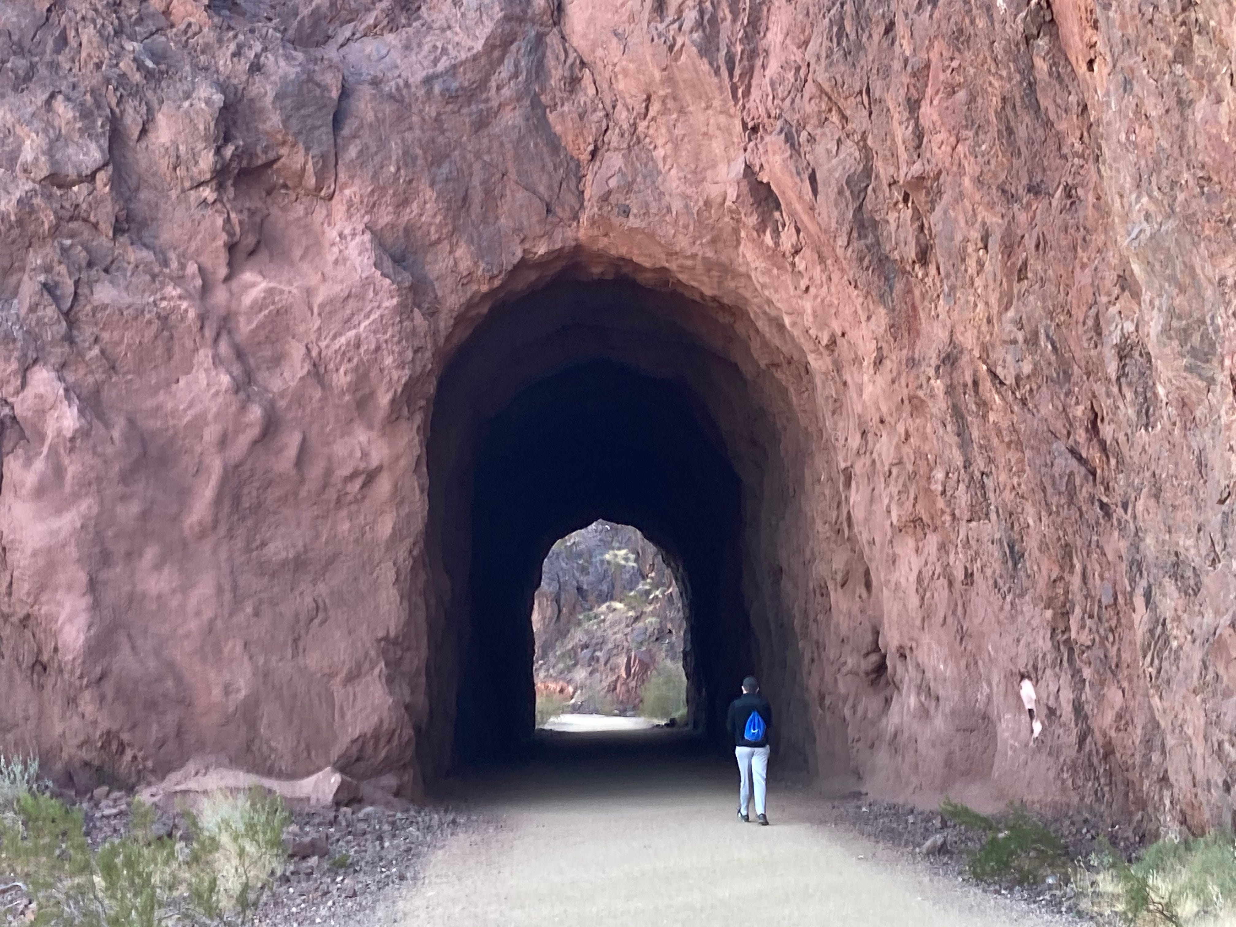
A 3.5-mile hardened gravel path (OK for bikes), known as the Historic Railroad Trail, is very popular, as it leaves from just below the main park visitor center and passes through five former railroad tunnels (BWO photo).
It’s coup de grace is a slow-motion approach to both 726-foot high Hoover Dam and the Mike O’Callaghan-Pat Tillman Memorial Bridge (BWO photo of Hoover Dam and Lake Mead’s bathtub ring from the bridge).


The bike trail leads to the dam’s massive parking structure, or you can cross the dam’s approach road to the parking area for walking across the bridge.The bridge carries Interstate 19 across the Colorado River. Its pedestrian sidewalk on the north side offers a unique view of the massive dam, as well as the Colorado River 890 feet below.
That’s one U.S. bridge that won’t wash out in the next flood (BWO photo).

Lake Mead, what’s left of it, stretches north beyond its confining canyon to the distant horizon as the country’s largest reservoir, though this may be in jeopardy as it continues to lose water.
Look to the south in the opposite direction to see the Colorado River leave the dam and enter Black Canyon, which eventually merges into Lake Mohave behind Davis Dam. The Lake Mead NRA has boundaries that reach all the way to the twin cities of Laughlin in Nevada and Bullhead City in Arizona, 60 miles downstream from Hoover Dam.
This section of Colorado River, and the first reservoir below Hoover Dam, is maintained relatively full of water, regardless of what’s happening at Lake Mead. Arizona and California pump much of their Colorado River water below here, from Lake Havasu, so those pumps need to be kept supplied. The flow out of Hoover Dam will change during the day due to water needed for electrical generation, so keep this in mind.
Las Vegas has built a pumping plant (viewable from the biking trail), with an underground/underwater syphon to the low part of Lake Mead not far behind Hoover Day.
NASA’s Earth Observatory blog gives a far better explanation of the Lake Mead water situation than I could. And here’s another report on the situation, from CNN.

Power boaters enjoy Lake Mohave because of its dependable water levels. Paddlers even get into the picture by using the 26-mile Lower Colorado River Black Canyon Water Trail, which begins near the base of Hoover Dam. You’ll want to do this one outside the hot season, from late October through March.

The Lake Mead National Recreation Area will continue to be a recreation mecca, no water what level its namesake waters reach.
On a side note, those who travel the West will learn that much of the upper Colorado River, at and below its headwaters in Rocky Mountain National Park, is diverted from west of the Continental Divide to be used east of the divide by Colorado’s growing Front Range cities.
Look for the Grand Ditch, on the west side of the national park, an obvious canal slicing across the upper slope of the Never Summer Range. It was conceived and started in 1890 to “steal” Colorado’s water and keep it in the state, rather than sending it toward California.
